
Whalebone Lane, bit of an odd name for a main road in a town not exactly famed for its whaling fleets, isn’t it? Well, the name derives from Whalebone House, that stood close to the junction of the modern-day High Road and Whalebone Lane. The house taking its name from the large whalebone arch that formed the main gate.
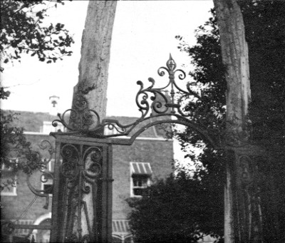
The house was destroyed in bombing in April 1941, not much survived, although the whalebones did, being transfered to Valance House, where they were recently rediscovered.
There had been a house on the site since at least 1667, the house shown in the photograph above dated from around 1747. What follows is a somewhat incomplete history of the house and owners:
- c1667 Owned by a Mr. Bell (no further details)
- c1747 Daniel Pilon constructed the house shown in the photograph.
- 1783 Nicholas Peter Pilon
- 1823 to 1846, used as a school by John Peacock
- 1846 to 1855, owned by the Mull family. Sold off on August 10th 1885 by auction.
- 1887 Alexander Anderson
- 1889 to 1917 Philip Savill and Mrs M. Savill
- 1920 Reginald Wood
- 1922 Walter Hayter
- before 1941, owned by Mrs Lester.
When exactly and why the whalebones made their appearance, I’ve not yet been able to discover – anyone know?
I am interested in more info regarding this house. I remember as a child around 1965 walking past this house on a daily basis walking with my mum from Marks Gate to Five Elms shops. The info given above states that the house was bombed out years earlier. From recollection the front garden had two very large trees, (one I think was a Monkey puzzle tree) and there was also a pond with large goldfish and lily pads afloat. The whalebones went from there to Valence house where they stayed for many years, but I don’t think they are there anymore. As a small child this house gave me many nightmares for some reason, and has always had a permanent place in my mind. {Should I take more tablets…???}
I hope you can shed some light……nostalga is great……Thanks.